Introduction
There are a number of geophysical techniques available for archaeological prospection. Magnetometry was chosen to cover this area after consideration of the geology and the potential nature of the known archaeological remains. It is a swift and efficient technique which works by measuring minor changes in the earth’s magnetic field, leading to the detection of many different types of features including kilns, hearths, ovens, ditches and walls, especially where ceramic material or tufa have been used in construction. However, the results of a magnetometer survey can be severely affected by areas of modern disturbance and in the presence of ferrous material where dipolar readings will be evident.
For the geophysical survey, grids of 30 x 30 m were set out using a Leica TC 805 Total Station. The grid was established to ensure the survey traverses crossed the alignment of the archaeology at 30º. A topographic survey was carried out to record both the nature and form of the land as well as features within the landscape such as buildings and roads enabling the survey to be accurately geo-referenced. The magnetometer survey was undertaken using the Bartington Grad601-2 Dual Array Twin Fluxgate Gradiometer. Readings were taken at 0.25 m intervals along traverses every 0.5 m within 30 x 30 m grids. The readings were recorded by the on-board Grad-01Data Logger. The Bartington Grad601-2 in some circumstances is able to detect buried features up to a depth of 3 m, although excessive modern debris and disturbance on or near the ground surface can affect the results, and make it impossible to survey certain areas.
Results
The close contour topographic survey (Figure 1) reveals the nature of the local topography very clearly. The ridge on which the settlement is located is clearly defined. The ridge is oriented NW-SE and the flat crest of the ridge runs along the SW part of the survey area. Prominent along the NE limit of the survey is the steep slope dropping down to a water channel running through a narrow gully. There is a ditch running WSW-ENE across the central section of the survey area which when overlaid on the cadastral map clearly corresponds with the modern field boundary.
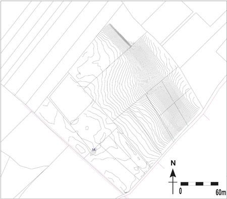
Figure 1: Topographic survey of the geophysical prospection area.
The magnetometer survey (Figures 2-3) covered an area of about 5 ha across the central part of the overall site at the intersection of the principal decumanus and cardo. Areas of deeply ploughed land were avoided as the effect of walking on ploughed soil that has not been harrowed can have a detrimental affect on the collection of good data. The overall results are exceptionally clear and the site has the benefit of not having been disturbed by modern ferrous material that causes disturbances in the results. Linear positive anomalies [m1] and [m2], aligned NNW-SSE and WSW-ENE, cross the survey area and represent the traces of modern field boundaries. Along the edges of these boundaries, and visible on the surface, are stone cairns built up of large limestone paving slabs from the ancient roads as a result of field clearance after ploughing. Traces of the plough marks can also be seen as very faint dark parallel bands across the entire survey area.
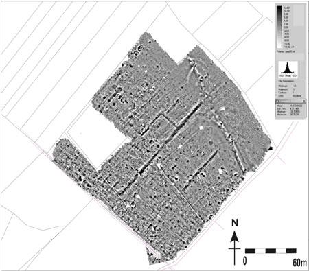
Figure 2: Results from magnetometry.
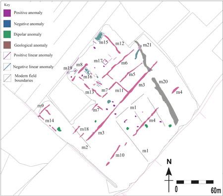
Figure 3: Interpretation of results from magnetometry.
The archaeological features differ only very slightly from the modern plough lines and field boundaries. The most striking feature that dominates the results is an orthogonal network of linear positive anomalies [m3], [m4], [m5], [m6], [m7], [m8], [m9], [m10], [m11], [m12], [m13] and [m14]. The orientation of anomalies [m2] to [m10] is NE-SW and the remaining ones lie perpendicular to them. These anomalies unmistakably represent the grid pattern of the ancient road system interlacing across the landscape. The positive signal suggests that the large limestone paving slabs that make up these roads are more magnetic than the soil around them. The traces of the roads in the results are of varying lengths due to the preservation of the sub-surface features and the field clearance described above has had obvious effects. Perhaps the most well preserved road is [m3]. It survives to a length of about 180 m and is about 5 m wide. It evidently drops down the slope of the ridge and continues northeasterly, towards the ditch suggesting the settlement continues beyond the natural gully. The anomaly [m4] and [m10] behave in a similar manner.
The interval between the NE-SW oriented roads [m3], [m4] and [m6] is about 50 m although there appears to be another road [m5] dividing the space between [m3] and [m6]. These roads are all linked by a perpendicular road [m11]. The interval between [m12], [m13] and [m14] appears to be about 85 m although there is evidence (including [m11]) that there may be other roads within this broad system perhaps indicating the presence of some form of smaller divisions in the form of insulae.
Between the network of roads, in the N part of the survey area, are a number of positive and negative anomalies clearly aligned to the infrastructure. The feature [m15] clearly conveys a rectangle in plan, measuring about 12 x 8 m, and it is suggested that this represents the remains of a building that has collapsed inwardly or indicates the presence of flooring contained within walls. The dipolar nature of the anomaly could also suggest burning activity. The same is true of the complex of anomalies [m16], lying to the southwest of [m15], seems to represent two adjacent square rooms, measuring about 5 x 5 m each, with flooring or collapse contained within them. There is one clear square positive feature [m17] that houses a positive amorphous anomaly. This structure may contain an area of flooring.
A parallel set of positive linear anomalies [m18] are evident near the SW limit of the survey area. It is very unclear what they could represent but they are well defined and prominent in the results. The most northerly one could signify a road on the same alignment as [m5] as it is aligned with this feature and not [m7].
There is one negative linear anomaly [m19] that does not conform to the alignment of the town’s layout. It is very unclear what this represents but could indicate a later structure as it appears to cut into a structure that is aligned with the town plan.
It is notable that the S area is devoid of defined anomalies. This strongly hints that ploughing here has destroyed much of the town although the roads remain largely in tact. Flanking the NE limit of the survey area is a feature [m20] that is both amorphous in form and in the nature its magnetic response. It is clearly a geological feature associated with the natural depression in the landscape. The area to the north of it is very “quiet” in terms of magnetic response and strongly suggests alluvial deposits. Associated with the geological feature is a strange anomaly [m21] that appears to “bridge” the geological feature. It is unclear what this feature may represent but it may indicate a cut through the geological strata as opposed to an archaeological feature.
Conclusions
Overall the pilot season of the magnetometer survey has proved highly successful in detecting the sub-surface features. The topographic plan of the area clearly sets the form and layout of the town into context. It is an invaluable resource when considering sites with such a complex topography and aids interpretation of features detected by the magnetometer. The layout of a site such as Interamna Lirenas is topographically dependent and the growth and development of the settlement will have been governed by the shape of the land it occupies.
Archaeologically, the main layout and axis of the town has been firmly established and the interconnecting road system may be denser than initially thought.
The presence of some structures in the N part of the survey area strongly suggests that preservation of buildings and other remains could potentially be greater towards the N of the site and bodes well for future seasons of survey work.
The dearth of archaeological remains in the S portion of the survey area is an interesting phenomenon and should be considered in tandem with surface collection survey.