Introduction
Systematic field-survey was carried out in the territories of Contrada Termine and Santa Lucia, both part of the Comune di Pignataro Interamna. This was done by parallel lines and by putting the surveyors (3-5) at a distance of 5 m from each other (intensive survey). Basic unit of the survey was the individual field defined as a consistent and bounded land plot with even visibility conditions (Unità Topografica – UT / lit. ‘Topographic Unit’). The ploughsoil assemblage distribution model here adopted hinged on site and offsite notions. Site was defined as a higher concentration of archaeological material with respect to the general situation within the Unità Topografica and therefore possible indicator of a past human settlement. Offsite was defined as a more diffused and less homogenous spread of archaeological material within the Unità Topografica, but nonetheless an indicator of some past human activity (e.g. manuring).
Conditions in the landscape (e.g. ploughing) were much varied and often inadequate in terms of surface visibility. Because of this and in order to achieve the best possible results, the systematic survey was carried out in limited and discontinuous areas. All sites were georeferenced by way of a GPS receiver, whilst altitudes were derived from the Carta Tecnica Regionale del Lazio Ril.1991 (i.e. the Regional Technical Map from Lazio 1991 edition, 1:10000).
All the following chronologies must be intended as earliest/latest attested dates.
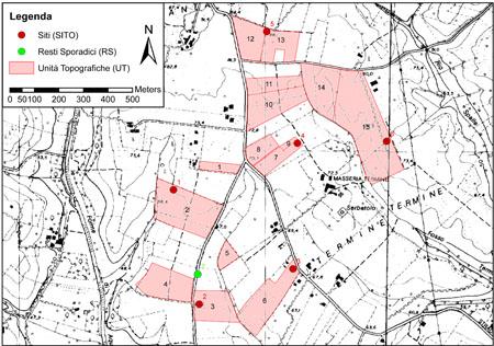
Fig.1: Distribution of Sites (SITO), Sporadic Remains (RS) and Topographic Units (UT) within the survey area (on Carta Tecnica Regionale del Lazio Ril. 1991 – Elementi 403130 e 403140)
Results
About 31 ha were surveyed at Contrada Termine and Santa Croce (Figure 1), for a total of 15 Topographic Units [UT 1-15], all characterised by excellent visibility conditions (generally recent ploughings):
- UT 1: background-noise offsite (generic Roman);
- UT 2: offsite of SITO 1 (350 BC – AD 300);
- UT 3: offsite of SITO 2 (300 BC – AD 1000);
- UT 4: background-noise offsite (AD 200-300);
- UT 5: background-noise offsite (350 BC – AD 1500);
- UT 6: offsite of SITO 3 (350 BC – AD 600);
- UT 7: offsite of SITO 4 (350 BC – AD 500);
- UT 8: background-noise offsite (200 BC – AD 300);
- UT 9: offsite of SITO 4 (AD 200-1500);
- UT 10: background-noise offsite (AD 100-1500);
- UT 11: background-noise offsite (generic Roman and Medieval);
- UT 12: background-noise offsite (AD 100-200);
- UT 13: offsite of SITO 5 (50-1 BC);
- UT 14: background-noise offsite (350-50 BC);
- UT 15: background-noise offsite / offsite of SITO 6 (350 BC – AD 1500).
Additionally 6 sites [SITO 1-6] have been identified (Figure 1):
- SITO 1 (UT 2): small farm (generic Roman);
- SITO 2 (UT 3): small/medium farm (350 BC – AD 800);
- SITO 3 (UT 6): small farm (350 BC – AD 500);
- SITO 4 (UT 7): medium farm (350 BC – AD 500);
- SITO 5 (UT 13): small farm (?) (generic Roman, but contrast with UT 13);
- SITO 6 (UT 15): medium/large farm (350 BC – AD 800).
This area had already been investigated by the Canadian team coordinated by E.M. Wightman and it seems appropriate to compare/contrast the two datasets – with the proviso that the Canadian team georeferenced spots with a 100-meters accuracy. It is therefore possible to suggest the following relations:
- UT 4 (background-noise offsite) = W353;
- UT 12 (background-noise offsite) = W309 e W312;
- UT 14 (background-noise offsite) = W313-314;
- SITO 4 = W316;
- SITO 6 = W317.
Concerning SITO 4 our research integrates what was already known with the recovery of black gloss pottery (Republican) and terra sigillata italica (Early Imperial), therefore providing new elements for a more accurate chronology. Nonetheless it is worth noticing that 13 Topographic Units (UT 1-3, 6-11, 13 e 15) and 4 sites (SITO 1-3, 5) have been identified and recorded for the very first time.
Conclusions
In general we have observed a high level of archaeological visibility throughout the survey area. This is due to favourable geomorphological conditions (a limited sedimentary process) and to the existence of extensive buried archaeology in connection with an intensive mechanised agricultural exploitation. The ploughsoil assemblage proved remarkable in terms of both quantity (ca. 58 finds/ha) and quality (several diagnostic sherds, ca. 8 per ha). Such conditions prompted the appropriate adoption of onsite sampling as our main collection strategy.
In terms of settlement patterns, our own evidence is still too limited and discontinuous to support any general re-interpretation or fresh argument. Nonetheless, one may notice the marked settlement continuity throughout the whole Roman period – and even beyond it.