Introduction
Systematic field-survey was carried out in the territories of Contrada Termine, Santa Croce and Ruscito, within the comuni of Piedimonte San Germano, Pontecorvo e Pignataro Interamna. This was done by parallel lines and by putting the surveyors (5-9) at a distance of 5 m from each other (intensive survey). Basic unit of the survey was the individual field defined as a consistent and bounded land plot with even visibility conditions (Unità Topografica – UT / lit. ‘Topographic Unit’). The ploughsoil assemblage distribution model here adopted hinged on site and offsite notions. Site was defined as a higher concentration of archaeological material with respect to the general situation within the Unità Topografica and therefore possible indicator of a past human settlement. Offsite was defined as a more diffused and less homogenous spread of archaeological material within the Unità Topografica, but nonetheless an indicator of some past human activity (e.g. manuring).
Conditions in the landscape in September (e.g. ploughing) were much varied and often inadequate in terms of surface visibility. Because of this and in order to achieve the best possible results, the systematic survey was carried out in limited and discontinuous areas. Much better conditions were met in October, us allowing us to fill the gaps in the coverage. All sites were georeferenced by way of a Garmin eTrex Venture HC GPS receiver, whilst altitudes were derived from the Carta Tecnica Regionale del Lazio Ril.1991 (i.e. the Regional Technical Map from Lazio 1991 edition, 1:10000).
All the following chronologies must be intended as earliest/latest attested dates.
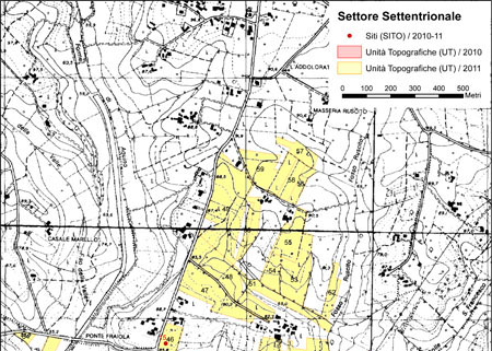
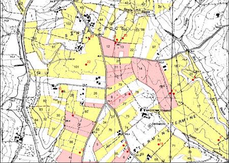
Fig.1: Distribution of Sites (SITO) and Topographic Units (UT) within the northern sector of the survey area (on Carta Tecnica Regionale del Lazio Ril. 1991 – Elementi 403130 e 403140)
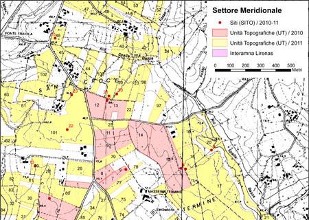
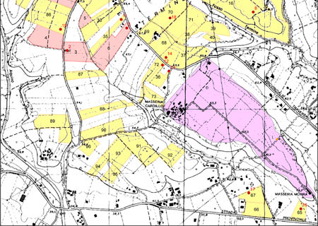
Fig.2: Distribution of Sites (SITO) and Topographic Units (UT) within the southern sector of the survey area (on Carta Tecnica Regionale del Lazio Ril. 1991 – Elementi 403130 e 403140)
Results
About 167 ha were surveyed at Contrada Termine, Santa Croce and Ruscito (Figures 1-2), for a total of 86 Topographic Units [UT 16-102], all characterised by excellent visibility conditions (generally recent ploughings):
- UT 16: background-noise off-site / offsite of SITO 8 (350 BC – AD 600);
- UT 17: background-noise off-site (Roman period);
- UT 18: background-noise off-site / offsite of SITO 7 (400-100 BC);
- UT 19: background-noise off-site (Roman and Medieval period);
- UT 20: archaeologically sterile area (see SITO 9);
- UT 21: background-noise off-site (Roman period);
- UT 22: background-noise off-site (Roman period);
- UT 23: background-noise off-site (200 BC – AD 300);
- UT 24: background-noise off-site (Roman period);
- UT 25: background-noise off-site (Roman period);
- UT 26: background-noise off-site (200 BC – AD 300);
- UT 27: background-noise off-site (50 BC – AD 200);
- UT 28: background-noise off-site (Roman period);
- UT 29: background-noise off-site / offsite of SITO 10 (50 BC – AD 200 and Medieval period);
- UT 30: background-noise off-site (Roman and Medieval period);
- UT 31: background-noise off-site (Roman and Medieval period);
- UT 32: background-noise off-site (Roman period);
- UT 33: background-noise off-site / probable offsite of a which cannot be precisely located (300 BC – AD 700 and Medieval period);
- UT 34: background-noise off-site (50 BC – AD 400);
- UT 35: background-noise off-site (350 BC – AD 550 and Medieval period);
- UT 36: Offsite of SITO 12 and 13 (200 BC – AD 550 and Medieval period);
- UT 37: background-noise off-site / offsite of SITO 14 (300 BC – AD 550 and Medieval period);
- UT 38: background-noise off-site (200 BC – AD 200);
- UT 39: background-noise off-site (Roman period);
- UT 40: background-noise off-site (Roman period);
- UT 41: background-noise off-site (Roman and Medieval period);
- UT 42: background-noise off-site (Roman period);
- UT 43: background-noise off-site (Roman and Medieval period);
- UT 44: background-noise off-site (200 BC – AD 300);
- UT 45: background-noise off-site (50 BC – AD 500);
- UT 46: background-noise off-site / offsite of SITO 15 (Roman and Medieval period);
- UT 47: background-noise off-site (150 BC – AD 450);
- UT 48: background-noise off-site (Roman period);
- UT 49: background-noise off-site (350 BC – AD 450 and Medieval period);
- UT 50: archaeologically sterile area;
- UT 51: background-noise off-site (200 BC – AD 500 and Medieval period);
- UT 52: background-noise off-site (Medieval period);
- UT 53: background-noise off-site (100 BC – AD 350 and Medieval period);
- UT 54: background-noise off-site (Roman and Medieval period);
- UT 55: background-noise off-site (200 BC – AD 300);
- UT 56: archaeologically sterile area;
- UT 57: archaeologically sterile area;
- UT 58: background-noise off-site (Roman and Medieval period);
- UT 59: background-noise off-site (Roman and Medieval period);
- UT 60: background-noise off-site (200 BC – AD 300);
- UT 61: background-noise off-site / offsite of a possible located immediately to NE (350 BC – AD 450);
- UT 62: background-noise off-site (300 BC – AD 600 and Medieval period);
- UT 63: background-noise off-site (Roman and Medieval period);
- UT 64: background-noise off-site (Medieval period);
- UT 65: = SITO 16;
- UT 66: Offsite of Interamna Lirenas (perhaps still part of the suburban area) (200 BC – AD 550 and Medieval period).
- UT 67: = SITO 17;
- UT 68: background-noise off-site / offsite of SITO 14 (300 BC – AD 700);
- UT 69: background-noise off-site (150 BC – AD 500);
- UT 70: Offsite of SITO 18 (300 BC – AD 600);
- UT 71: background-noise off-site (300 BC – AD 350);
- UT 72: background-noise off-site (300 BC – AD 300);
- UT 73: background-noise off-site (Roman period);
- UT 74: background-noise off-site (300 BC – AD 300);
- UT 75: background-noise off-site (250-75 BC);
- UT 76: background-noise off-site (200 BC – AD 600);
- UT 77: background-noise off-site (300 BC – AD 550);
- UT 78: background-noise off-site (Roman period);
- UT 79: background-noise off-site (Roman period);
- UT 80: background-noise off-site (Roman and Medieval period);
- UT 81: archaeologically sterile area;
- UT 82: background-noise off-site (Roman period);
- UT 83: background-noise off-site (Roman period);
- UT 84: archaeologically sterile area;
- UT 85: background-noise off-site (300-1 BC);
- UT 86: offsite of SITO 19 (300 BC – AD 550);
- UT 87: background-noise off-site (300 BC – AD 700);
- UT 88: background-noise off-site (AD 200-700);
- UT 89: background-noise off-site (200 BC – AD 300 and Medieval period);
- UT 90: background-noise off-site (200 BC – AD 425);
- UT 91: background-noise off-site (350 BC – AD 550 and Medieval period);
- UT 92: background-noise off-site (350 BC – AD 550);
- UT 93: background-noise off-site (350 BC – AD 300 and Medieval period);
- UT 94: background-noise off-site (150 BC – AD 450);
- UT 95: background-noise off-site (200 BC – AD 200);
- UT 96: background-noise off-site (Roman period);
- UT 97: background-noise off-site (Roman and Medieval period);
- UT 98: background-noise off-site (200 BC – AD 200);
- UT 99: background-noise off-site / offsite of SITO 20 and 21 (350 BC – AD 500);
- UT 100: background-noise off-site (300-200 BC);
- UT 101: background-noise off-site / offsite of SITO 22 and 23 (225 BC – AD 500 and Medieval period);
- UT 101: background-noise off-site (300 BC – AD 550 and Medieval period).
Additionally 17 sites [SITO 7-23] have been identified (Figures 1-2):
- SITO 7 (UT 18): small/medium rural site (225 BC – AD 500) = SITO 6;
- SITO 8 (UT 16): small rural site (200 BC – AD 500);
- SITO 9 (UT 20): possible small service building or dump (Roman period)
- SITO 10 (UT 29): small rural site (350 BC – AD 500 and Medieval period);
- SITO 11 (UT 35): alla cappuccina tomb (?) (200 BC – AD 400);
- SITO 12 (UT 36): necropolis (?) (200-100 BC) = SITO 13;
- SITO 13 (UT 36): necropolis (?) (200 BC – 300 d.C.) = SITO 12;
- SITO 14 (UT 37): extra-urban sanctuary (400 BC – AD 650);
- SITO 15 (UT 46): small rural site or necropolis (50 BC – AD 300 and Medieval period);
- SITO 16 (UT 65): suburban extension of Interamna Lirenas (200 BC – AD 500);
- SITO 17 (UT 67): suburban extension of Interamna Lirenas (200 BC – AD 600 and Medieval period);
- SITO 18 (UT 70): small/medium rural site (300 BC – AD 600);
- SITO 19 (UT 86): small/medium rural site (350 BC – AD 350);
- SITO 20 (UT 99): medium rural site (350 BC – AD 550);
- SITO 21 (UT 99): medium rural site (350 BC – AD 700);
- SITO 22 (UT 101): small rural site (300 BC – AD 700);
- SITO 23 (UT 101): small rural site (300 BC – AD 550).
This area had already been investigated by the Canadian team coordinated by E.M. Wightman and it seems appropriate to compare/contrast the two datasets – with the proviso that the Canadian team georeferenced spots with a 100-meters accuracy. It is therefore possible to suggest the following relations [W=Wightman]:
- UT 18 = W319;
- UT 49 = W261;
- UT 55 = W262;
- UT 60 = W300 and W303;
- UT 76 = W358;
- UT 89 = W357;
- SITO 8 = W365;
- SITO 11 = W360;
- SITO 14 = W363 (sanctuary)
- SITI 20-21 = W310 (group of sites)
- SITO 22 = W306
As for SITO 20-21 (=W310) our research allows a better definition of the nature of the settlement, actually being more articulated than originally guessed (group of houses). Furthermore, data gathered in relation to SITO 22 (=W306) make it possible to derive a more precise chronology beyond a generic ‘Roman period’. It is also worth noting that 75 Topographic Units (UT 16-17, 19, 21-48, 51-54, 58-59, 61-75, 77-80, 82-83, 85-88 e 90-102) and12 sites (SITO 7, 9-10, 12-13, 15-19 e 23) have been identified and recorded for the very first time.
Conclusions
In general we have observed a high level of archaeological visibility throughout the survey area (only 5 Topographic Units did not produce any archaeological find: UT 50, 56, 57, 81 and 84). This is due to favourable geomorphological conditions (a limited sedimentary process) and to the existence of an extensive buried archaeology in connection with an intensive mechanised agricultural exploitation. The ploughsoil assemblage proved remarkable in terms of both quantity and quality. Such conditions prompted the appropriate adoption of onsite sampling as our main collection strategy.
Although our own evidence is still too limited and discontinuous to support any general re-interpretation or fresh argument, it is already possible to outline some working hypothesis concerning ancient settlement patterns. First of all, it is likely that the plain immediately to the S of Interamna Lirenas was occupied in some way (SITO 16-17), probably as a suburban extension of the main centre. This can be readily explained in relation to the road network itself and makes perfect sense with the presence of an ‘extra-urban’ thermal complex (so-called Dogana). Moving northwards from town (along the via Latina), one finds traces of a votive area (so-called ‘sanctuary’) and of a necropolis and/or individual tombs (SITO 12-13). In the area to the W of Interamna (UT 88-96) no sites were found and even the Canadian survey did only identify one (W364), to the margins of UT 90. Future survey-campaigns will allow a better understanding of this issue.
Rural sites – generally of medium/small size – are primarily located along flat ridges and start to appear already within a 500-m-radius from the urban centre (SITO 18). Moving northwards, geomorphology becomes more marked (steep slopes) and the number and size of areas suitable to settlement gets drastically reduced. In these cases, rural sites tend to gather on relatively small spots that overlook large cultivable areas (SITI 5, 20-21). This settlement pattern is perhaps confirmed by the area made up of UT 47-59, all these off-sites being located around groups of modern houses that it has been not possible to survey. Indeed, all these fields have produced archaeological finds that one could interpret as displaced down from overlying ancient settlements, now overbuilt and therefore not clearly identifiable. Put in a nutshell, whereas topography is such as to present gentle slopes and open areas (Contrada Termine), sites do appear quite dispersed (e.g. SITO 1, 2, 3, 4, 6/7, 10, 18 and 19). On the other hand, whereas the landscape becomes more ‘broken’, settlement nucleation is the dominant pattern (e.g. SITI 5, 20-21).
More in general one cannot but take note of the fact that there are strong signs of settlement continuity throughout all the Roman period and much beyond it