Introduction
There are a number of geophysical techniques available for archaeological prospection. Magnetometry was chosen to cover this area after consideration of the geology and the potential nature of the known archaeological remains. It is a swift and efficient technique which works by measuring minor changes in the earth’s magnetic field, leading to the detection of many different types of features including kilns, hearths, ovens, ditches and walls, especially where ceramic material or tufa have been used in construction. However, the results of a magnetometer survey can be severely affected by areas of modern disturbance and in the presence of ferrous material where dipolar readings will be evident.
For the geophysical survey, grids of 30 x 30 m were set out using a Leica TC 805 Total Station. The grid was established to ensure the survey traverses crossed the alignment of the archaeology at 30º. A topographic survey was carried out to record both the nature and form of the land as well as features within the landscape such as buildings and roads enabling the survey to be accurately geo-referenced. The magnetometer survey was undertaken using the Bartington Grad601-2 Dual Array Twin Fluxgate Gradiometer. Readings were taken at 0.25 m intervals along traverses every 0.5 m within 30 x 30 m grids. The readings were recorded by the on-board Grad-01Data Logger. The Bartington Grad601-2 in some circumstances is able to detect buried features up to a depth of 3 m, although excessive modern debris and disturbance on or near the ground surface can affect the results, and make it impossible to survey certain areas.
Results
The close contour topographic survey (Figure 1) reveals the nature of the local topography very clearly. The ridge on which the settlement is located is more clearly defined than it was in 2010. The detail recovered by the latest survey has revealed many more intricate features that define the urban landscape. The main ridge [A] is oriented northwest-southeast and the flat crest of the ridge runs along the central part of the survey area. Still prominent along the north-eastern limit of the survey is the steep slope [B] dropping down to a water channel running through a narrow gully. The mirror image of the steep decline on the western side of the ridge is now also well illustrated in the extreme southwest corner of the survey area [C]. Although the main ridge is very flat there is one particular elongated area [D] oriented northeast-southwest that straddles the ridge. In the northern extremes of the survey area, in Area 4, the topography clearly indicates the downward slope of the terrain towards the north [E] into a shallow basin beyond. There is a ditch running northeast-southwest [F] across the central section of the survey area which when overlaid on the cadastral map clearly corresponds with the modern field boundary.
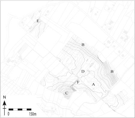
Figure 1: Topographic survey of the geophysical prospection area (2010-11).
The magnetometer survey from both seasons (Figures 2-3) covers an area of about 15 ha focussed on the central part of the site flanking both sides of the via Latina. One area on the northern margins of the town was also surveyed. The overall results are exceptionally clear and in general, the site has the benefit of not having been disturbed by modern ferrous material that causes disturbances in the results. There was certainly one exception to this. In Area 2 there was a very large dipolar anomaly that measured about 20 by 20m, marked on the results by a red ‘X’ (Figure 3). This feature is undoubtedly modern and given the proximity of the site to Monte Cassino it cannot be overlooked that this may represent military ordnance (potentially unexploded) from the Second World War.
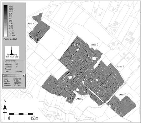
Figure 2: Results from magnetometry (2010-11).
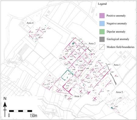
Figure 3: Interpretation of results from magnetometry (2010-11).
Anomalies [m1] to [m21] in Area 1 are discussed in the geophysical survey report of 2010.
There are numerous linear positive anomalies aligned NNW-SSE and WSW-ENE, across the survey area and these represent the traces of modern field boundaries. Along many of the edges of these boundaries, and visible on the surface, are stone cairns built up of large limestone paving slabs from the ancient roads as a result of field clearance after ploughing. Traces of the plough marks can also be seen as very faint dark parallel bands across the entire survey area.
The most striking feature that dominates the results is a complex orthogonal network of linear positive anomalies [m22] to [m49] oriented northeast-southwest with a corresponding perpendicular alignment. These anomalies unmistakably represent the grid pattern of the ancient road system interlacing across the landscape and oriented on the via Latina [vL]. A narrow negative anomaly appears to trace much of the course of the via Latina and this is most likely a water conduit. The positive signal detected for the roads suggests that the large limestone paving slabs that make up these roads are more magnetic than the soil around them. The traces of the roads in the results are of varying lengths due to the preservation of the sub-surface features and the field clearance described above has had obvious effects. This orthogonal system, identified in the 2010 pilot season, is now far more clearly visible and extends across the site.
What is evident in Area 2, the area directly north of the 2010 survey area, is the division of the urban landscape into well-defined insulae blocks created by the road layout. The clarity of the road system, consisting of [m22] to [m34] and [m54], depicts a much more regular grid layout than witnessed in the initial season’s results although there are evident continuations of the roads identified in Area 1. The interval between the northwest-southeast roads ranges from between 30 and 50m and between the northeast-southwest roads the range is about 50 and 85m.
Just as in Area 1, the northeast-southwest roads [m23], [m24], [m27] and [m28] can be seen to continue beyond the change in geology [m53] along the northern perimeter of the survey. In Area 1 this geological change was denoted by a band of varying magnetic responses [m20]. In Area 2 the contrast of the anomaly is less severe but the “quietness” of the magnetic response to the north of the feature suggesting an accumulation of alluvial deposits just as identified in Area 1. This evidence strongly supports the theory that this natural depression does not demarcate the edge of the Roman town.
In Area 4, the northern extreme of the survey area on the margins of the urban settlement, there is clear evidence for the continuation of the orthogonal layout of the road systems [m48] to [m51]. The proportions and alignment of the road layout adhere to that seen in Areas 1, 2 and 3. What is abundantly clear is the fact that traces for the extension of the town north of roads [m50] and [m51] are not present at all. There is strong evidence for this being the limit of the town and perhaps the given the natural topography in this area there was no need for a defensive town wall.
Area 5 has a very different composition. Only one clear road can be seen [m52] on a northeast-southwest alignment and lies about 50m east of the modern track that follows the course of the Roman road. Beyond this feature, to the south, there is absolutely no trace of the layout of any infrastructure. In fact the majority of the southern half of this area is notable for its total lack of features.
The strong evidence for the presence of an orthogonal road system naturally creates insulae blocks. Although of varying sizes, the general pattern across the site is fairly uniform and most measure about 50 by 40m. The results clearly indicate a prolific spread of dense urban occupation across the site denoted by the linear positive and negative anomalies aligned to the street layout. Rather than address each anomaly individually it is perhaps more pertinent to discuss the major insulae and their characteristic and prominent features.
The insula [m55] in the northern part of Area 2 measures 40 by 50m. It contains a large dipolar anomaly that could be related to a burning process (kiln?) or construction in tiles or bricks, both of which would be represented by a very positive magnetic value. There is clear evidence of structural remains around this large anomaly both in the form of linear positive and negative features. South of this, insula [m56] looks to be a smaller in size measuring 30 by 50m. There is a distinct lack of structural evidence in this block. Insula [m57] has a slightly more dense series of linear anomalies indicating occupation but no clear complex of buildings can be identified. Bordering the via Latina, insula [m58] contains a series of regular positive linear anomalies flanking the roadside. These could represent shop fronts given their position and size.
Insulae [m59], [m60] and [m61] are of varying sizes but are all characterised by a dense array of structural remains. The presence of both negative and positive anomalies indicates that there is most likely a contrast in building material used on site. Immediately north of the last three insulae is [m62]. Curiously this block appears to be characterised by a large open space with very few traces of structural remains other than a circular anomaly in its centre. It is obviously unclear whether this is a product of an intentional, genuine lack of remains or destruction of what was originally there. Apparent in insula [m63] is a long rectangular structure denoted by a negative anomaly measuring about 15 by 50m.
Insula [m64] has a series of structural remains that are represented by negative linear anomalies. The positive anomalies contained within these, may indicate the presence of flooring. Both [m65] and [m66] are characterised by some structural remains. The northern corner of insula [m65] has a high density of amorphous positive anomalies. Although unclear as to what these represent they are evidently significant.
Immediately to the north, is insula [m67]. It is instantly apparent that this insula is in fact probably composed of one large building. The details evident in the results suggest a single rectangular building measuring about 40 by 55m. The lateral walls are clearly constructed of a building material with a higher magnetic property than that of the surrounding soil as the response is highly positive. The central section of the building appears to have small internal divisions with a possible central hall or courtyard. There appears to be evidence of small circular anomalies at regular intervals along the lateral walls which suggest the presence of rows of columns. It is certainly a substantial structure and perhaps its location, size and layout could betray its function. To the east of this insula is a large open court [m68] measuring about 45m wide and 100m long and oriented northeast-southwest. This is undoubtedly the town’s forum. What are unclear are the actual dimensions. Unfortunately the dense vegetation along the field boundary in the vicinity of the supposed northern perimeter of the forum obscures an accurate measurement of the length of the forum. It appears as though the northwest-southeast road [m54] juts out into the forum so making its length about 100m. What is perhaps most noteworthy is the fact that the forum does not lie lengthways along the via Latina as in, for example, Fregellae. A similar layout, however, is to be found in the town of Minturnae on the coast. Along the east and west sides of the forum are a series of circular positive anomalies spaced at regular intervals along a line [m69] and [m70]. These could denote the presence of a colonnaded portico flanking each side of the forum.
The identification of the civic centre of the town aids the interpretation of the surrounding buildings if only to suppose they are public buildings and not private domestic spaces. Thus [m67] could be a major public monument (macellum/market?). Flanking the north-western side of the forum is a long and narrow insula [m71]. There are few obvious internal divisions and the assumption is that this could be a basilica or other public building associated with the civic centre. Directly north of this is a small insula [m72] which appears largely devoid of internal structures except for one central anomaly. This anomaly could represent an altar inside a small temple.
Insula [m73] is characterised by the presence of a very strong positive/dipolar curvilinear anomaly that defines its outline. This is most likely to indicate a lead pipe. The pipe traces the routes of the roads and it is likely that a pipe of this scale could feed a public fountain or be associated with a bath complex. Given the proximity of this feature to the main civic centre, a bath complex would not be unusual. Insula [m74] is situated at the southern extent of the forum on the south side of the via Latina. Internally it is characterised by a large negative rectilinear anomaly which could represent one large public monument. It is not clear the function of this building but it does also stand on the crest of the ridge overlooking the valley to the south and so possesses a prominent location both in the town itself and in the landscape. Flanking the forum to the east is a series of structural remains [m75] that could represent another public building whether it is a market or temple. There is not enough detail to assign a function but the strategic position does infer that it should be a public monument.
Insula [m76] is located immediately south of [m74] and its extent is clearly defined by the roads around it. There is, however, scant evidence of structural remains within the insula. This is a trend that continues south and west of this insula. To the south, the land begins to drop away steeply and there may be evidence for a change in the geology [m84] but certainly no evidence for structural or occupational remains. It is very unclear but there is potentially a positive anomaly [m85] that could represent the traces of a road heading sharply downslope. This is very unclear however.
Insula [m77] is clearly characterised by faint linear anomalies that suggest the presence of structures aligned to the overall orientation of the town. The density of building remains in this insula is in stark contrast with the one immediately south, [m78] which lacks any rectilinear features. In terms of topography this area is on the very edge of the presumed occupied territory.
Insula [m79], in the northern extreme of the survey area, shows evidence for one of the most densely occupied insula blocks with a complex series of positive and negative linear anomalies. There is certainly a substantial building in the southwest corner of the insula and it may be associated with a circular feature beyond. It is unclear what the function of this building is but it does possess different characteristics to the rest of the structural remains in the insula. In the insula to the north, [m80], the density of structural remains diminishes somewhat and it may be overburden that obscures the detection of the structural remains. To the north of both these insulae there is a noticeable absence of any structural remains leading to the conclusion that this is the northern limit of the occupied settlement.
Area 5 displays a complete lack of organised and defined insulae. There are some very faint traces of structural remains flanking the edge of the via Latina [m81] but there is no clear layout or form. A field boundary [m82] marks a distinct change in the results. Everything south and east of this division appears to have been ‘stripped’ away leaving no traces of archaeological remains. It is possible that differential ploughing could have caused this phenomenon. However, it is curious that Area 5 in general is devoid of linear structural remains and that the majority of anomalies appear to be pit-like in nature [m82].
Conclusions
Overall the second season of the magnetometer survey has again proved highly successful in detecting the sub-surface features. The topographic plan of the area clearly sets the form and layout of the town into context. A detailed close contour survey is an invaluable resource when considering sites with such complex topography and aids interpretation of features detected by the magnetometer. The layout of a site such as Interamna Lirenas is topographically dependent and the growth and development of the settlement will have been governed by the shape of the land it occupies.
Our understanding of the layout and axis of the town has been extended and the interconnecting road system may be denser than initially thought. The orthogonal grid layout is so clear and regular in Area 2 but completely lacks any form of definition in Area 5. Perhaps most significant was the identification of the main civic centre in the form of a long forum. The orientation of the forum northeast-southwest is surprising as it causes the short side of the forum to open onto the via Latina. Associated with this large colonnaded public space are possible substantial public buildings and monuments. The results are not clear-cut but certainly there could be evidence for public buildings usually associated with fora: some small sacred edifices, a basilica and possibly a market.
Overall the well-defined insula blocks display dense patterns of structural and occupational evidence but it is worth noting that towards the periphery to the northeast, south and southwest of the town the evidence for occupation diminishes substantially. This phenomenon is perhaps best illustrated by the dearth of archaeological remains in Area 5. This stark contrast to the evidence for occupation over the rest of the surveyed area is interesting and should be considered in tandem with surface collection survey.